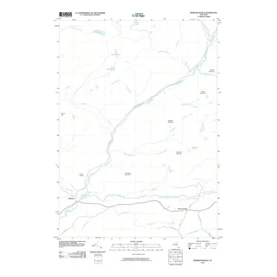
2010 Map of Morehouseville
USGS Topo · Published 2010About this map
Morehouseville and Nobleboro anchor this southern Adirondack region, where the South Branch West Canada Creek joins the main flow of West Canada Creek. The landscape is defined by a series of prominent peaks, including Fort Noble Mountain, Spruce Mountain, and Baldface Mountain, interspersed with wetlands such as Threemile Vly and Bethune Vly. The transportation network is relatively sparse, consisting of local routes like Haskell Rd and French Rd that navigate the valleys between these heights. Notable topographical transitions are evident at Green Clearing and Jacks Falls. This map highlights the area's transition from waterway-oriented settlement to a modern landscape of managed forest and high peaks, offering clear documentation of the region's hydrography and elevation just before the turn of the decade.
Find a feature on this map
36 named features on this map. Tap any name to fly to it.
Don’t see what you’re looking for? This feature index may not catch every label — zoom into the map to look around manually.
Map Details
Editions of this 2010 Morehouseville Map
This is the sole edition of this map. No revisions or reprints were ever made.
Other maps of this area

1900 · Canada Lake
USGS Topo · 1:62,500

1900 · Wilmurt
USGS Topo · 1:62,500

1901 · Old Forge
USGS Topo · 1:62,500

1902 · Wilmurt
USGS Topo · 1:62,500

1903 · West Canada Lakes
USGS Topo · 1:62,500

1904 · Piseco Lake
USGS Topo · 1:62,500

1906 · Piseco Lake
USGS Topo · 1:62,500

1908 · Piseco Lake
USGS Topo · 1:62,500

1950 · Utica
USGS Topo · 1:250,000
1954 · Ohio
USGS Topo · 1:62,500