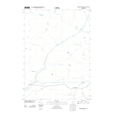
2013 Map of Morehouseville
USGS Topo · Published 2013About this map
West Canada Cr and its southern branch define the drainage of this Herkimer County landscape, where the small settlements of Morehouseville and Nobleboro sit along the primary road corridors. The area is characterized by a series of named heights, including Ft Noble Mtn, Bethune Mtn, and Baldface Mtn, which rise between a network of wetlands and brooks. Transportation is centered on local routes such as Jones Rd and Hurter Rd, with the Fayle Road Bridge providing a key crossing point. This map documents a high-altitude wilderness character, punctuated by clearings like Green Clearing and numerous small water bodies such as Gid Lake and Little Salmon Lake. The intricate stream systems, including Honnedaga Brook and Metcalf Brook, suggest a terrain primarily shaped by its waterways and timber-covered slopes.
Find a feature on this map
35 named features on this map. Tap any name to fly to it.
Don’t see what you’re looking for? This feature index may not catch every label — zoom into the map to look around manually.
Map Details
Editions of this 2013 Morehouseville Map
This is the sole edition of this map. No revisions or reprints were ever made.
Other maps of this area

1900 · Canada Lake
USGS Topo · 1:62,500

1900 · Wilmurt
USGS Topo · 1:62,500

1901 · Old Forge
USGS Topo · 1:62,500

1902 · Wilmurt
USGS Topo · 1:62,500

1903 · West Canada Lakes
USGS Topo · 1:62,500

1904 · Piseco Lake
USGS Topo · 1:62,500

1906 · Piseco Lake
USGS Topo · 1:62,500

1908 · Piseco Lake
USGS Topo · 1:62,500

1950 · Utica
USGS Topo · 1:250,000
1954 · Ohio
USGS Topo · 1:62,500