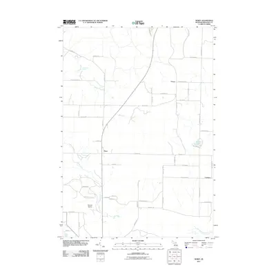
2011 Map of Morey
USGS Topo · Published 2011About this map
Pioneer and Morey serve as focal points for this Missaukee County landscape, where the headwaters of several drainages shape the rural terrain. The northern reaches are defined by the Ham Creek Spring and the winding course of Ham Creek, while the southern portion of the quadrangle includes the Missaukee Mountain Ski Area, situated just west of the valley formed by Hopkins Creek. This area illustrates a typical northern Michigan pattern of dispersed rural settlement along a grid of section roads such as N Morey Rd and W Moorestown Rd. Small bodies of water, including Loon Lake and Dyer Lake, dot the landscape alongside the West Branch Muskegon River in the southeast corner. The presence of the ski area near Cutcheon highlights the transition from traditional agriculture and timber interests to modern seasonal recreation in the late twentieth and early twenty-first centuries.
Find a feature on this map
46 named features on this map. Tap any name to fly to it.
Don’t see what you’re looking for? This feature index may not catch every label — zoom into the map to look around manually.
Map Details
Editions of this 2011 Morey Map
This is the sole edition of this map. No revisions or reprints were ever made.
Other maps of this area

1954 · Traverse City
USGS Topo · 1:250,000

1956 · Kalkaska
USGS Topo · 1:62,500

1956 · Fife Lake
USGS Topo · 1:62,500

1956 · Cadillac North
USGS Topo · 1:62,500

1956 · Lake City
USGS Topo · 1:62,500

1958 · Traverse City
USGS Topo · 1:250,000

1983 · Cadillac
USGS Topo · 1:100,000

1983 · Stittsville
USGS Topo · 1:24,000

1983 · Lake City
USGS Topo · 1:25,000
1983 · Dinca
USGS Topo · 1:25,000