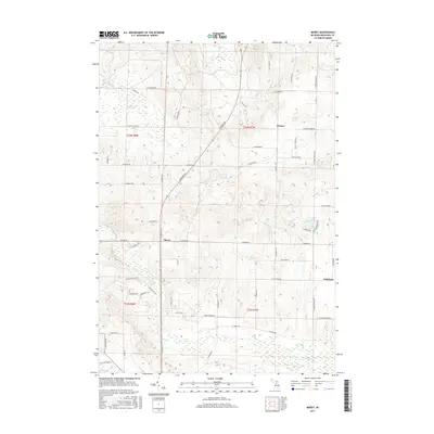
2017 Map of Morey
USGS Topo · Published 2017About this map
Pioneer and the crossroads at Morey anchor this northern Missaukee County landscape, where the agricultural grid meets the drainage systems of the Upper Muskegon watershed. The terrain is defined by glacial features, including the Ham Creek Spring and the meandering path of Ham Cr, which winds through the northwestern corner of the quadrangle. In the southeast, the village of Cutcheon sits near the headwaters of the W Br Muskegon River, illustrating the historic reliance of these settlements on local hydrology and timber resources. Evidence of modern residential expansion appears near Dyer Lake and Loon Lake, where planned subdivisions like the Missaukee Hills area deviate from the township's traditional section-line road network. This survey documents the transition from isolated rural post offices to contemporary Michigan communities organized around the county's numerous lakes and tributary creeks.
Find a feature on this map
47 named features on this map. Tap any name to fly to it.
Don’t see what you’re looking for? This feature index may not catch every label — zoom into the map to look around manually.
Map Details
Editions of this 2017 Morey Map
This is the sole edition of this map. No revisions or reprints were ever made.
Other maps of this area

1954 · Traverse City
USGS Topo · 1:250,000

1956 · Kalkaska
USGS Topo · 1:62,500

1956 · Fife Lake
USGS Topo · 1:62,500

1956 · Cadillac North
USGS Topo · 1:62,500

1956 · Lake City
USGS Topo · 1:62,500

1958 · Traverse City
USGS Topo · 1:250,000

1983 · Cadillac
USGS Topo · 1:100,000

1983 · Stittsville
USGS Topo · 1:24,000

1983 · Lake City
USGS Topo · 1:25,000
1983 · Dinca
USGS Topo · 1:25,000