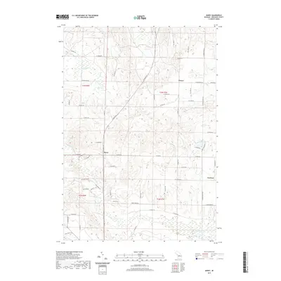
2019 Map of Morey
USGS Topo · Published 2019About this map
Morey and Pioneer anchor this northern Missaukee County landscape, where the headwaters of the W Br Muskegon River emerge from low-lying wetlands. The terrain is defined by glacial features, evidenced by the clustered waters of Loon Lake and the flowing systems of Ham Cr and Hopkins Cr. Local history is centered at the Pioneer Cem and the settlement of Cutcheon to the southeast, while the section-line road grid—including N Morey Rd and W Moorestown Rd—reflects the systematic 19th-century survey of the Michigan interior. Modern residential development is visible in the southwest quadrant near Missaukee Hills Dr, contrasting with the more dispersed rural layout of the northern reaches near Ham Creek Spring.
Find a feature on this map
50 named features on this map. Tap any name to fly to it.
Don’t see what you’re looking for? This feature index may not catch every label — zoom into the map to look around manually.
Map Details
Editions of this 2019 Morey Map
This is the sole edition of this map. No revisions or reprints were ever made.
Other maps of this area

1954 · Traverse City
USGS Topo · 1:250,000

1956 · Kalkaska
USGS Topo · 1:62,500

1956 · Fife Lake
USGS Topo · 1:62,500

1956 · Cadillac North
USGS Topo · 1:62,500

1956 · Lake City
USGS Topo · 1:62,500

1958 · Traverse City
USGS Topo · 1:250,000

1983 · Cadillac
USGS Topo · 1:100,000

1983 · Stittsville
USGS Topo · 1:24,000

1983 · Lake City
USGS Topo · 1:25,000
1983 · Dinca
USGS Topo · 1:25,000