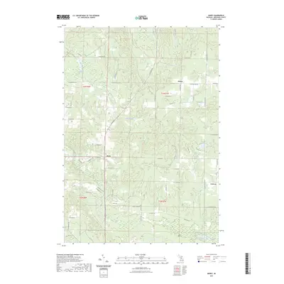
2023 Map of Morey
USGS Topo · Published 2023About this map
Pioneer and the settlement of Morey anchor this northern Michigan landscape, characterized by a grid of rural roads and the undulating elevations of the Missaukee Hills. The area is defined by its water systems and timber-inflected geography, where Ham Creek and Ham Creek Spring feed into the surrounding lowlands. A network of recreational routes, including the North Missaukee Trl and Lp651 Trl, crisscrosses the township lines, revealing how the land is used for both transit and forestry. In the southeast corner, the West Branch Muskegon River flows past the small community of Cutcheon, while Loon Lake sits near the eastern boundary. Genealogists will find the Pioneer Cem a significant landmark for tracing local family history in this quiet corner of Missaukee County.
Find a feature on this map
55 named features on this map. Tap any name to fly to it.
Don’t see what you’re looking for? This feature index may not catch every label — zoom into the map to look around manually.
Map Details
Editions of this 2023 Morey Map
This is the sole edition of this map. No revisions or reprints were ever made.
Other maps of this area

1954 · Traverse City
USGS Topo · 1:250,000

1956 · Kalkaska
USGS Topo · 1:62,500

1956 · Fife Lake
USGS Topo · 1:62,500

1956 · Cadillac North
USGS Topo · 1:62,500

1956 · Lake City
USGS Topo · 1:62,500

1958 · Traverse City
USGS Topo · 1:250,000

1983 · Cadillac
USGS Topo · 1:100,000

1983 · Stittsville
USGS Topo · 1:24,000

1983 · Lake City
USGS Topo · 1:25,000
1983 · Dinca
USGS Topo · 1:25,000