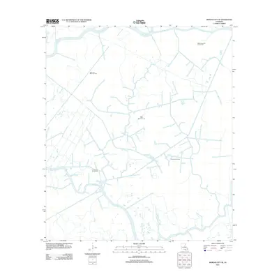
2012 Map of Morgan City SE
USGS Topo · Published 2012About this map
Wallace Bayou Oil and Gas Field and several other significant energy production zones define this low-lying landscape south of Bayou Black. This part of Terrebonne Parish is characterized by a dense network of natural and engineered waterways, where the Burke Canal cuts through terrain dominated by the wandering paths of Bayou Chene and Kent Bayou. The map reveals a highly specialized industrial geography centered on extraction, with the North Kent Bayou Gas Field and Turtle Bayou Gas Field occupying the marshy interstices between larger water bodies. The prevalence of these named fields suggests a landscape deeply integrated into the state's petroleum economy. Navigable waters like Bayou Penchant serve as the primary structural features of the area, illustrating how local industry and hydrology are inextricably linked in this coastal environment.
Find a feature on this map
11 named features on this map. Tap any name to fly to it.
Don’t see what you’re looking for? This feature index may not catch every label — zoom into the map to look around manually.
Map Details
Editions of this 2012 Morgan City SE Map
This is the sole edition of this map. No revisions or reprints were ever made.
Other maps of this area

1892 · Gibson
USGS Topo · 1:62,500

1894 · Bayou De Large
USGS Topo · 1:62,500

1897 · Gibson
USGS Topo · 1:62,500

1932 · Lake Decade
USGS Topo · 1:62,500

1935 · Morgan City
USGS Topo · 1:62,500

1935 · Lake Penchant
USGS Topo · 1:31,680

1939 · Gibson
USGS Topo · 1:62,500

1940 · Bayou Du Large
USGS Topo · 1:62,500

1941 · Bayou Du Large
USGS Topo · 1:62,500
1941 · Gibson
USGS Topo · 1:62,500