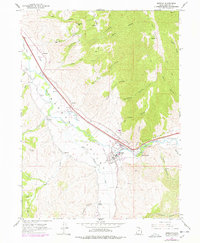
1961 Map of Morgan
USGS Topo · Published 1978About this map
Morgan sits at the heart of Morgan Valley, where the Weber River is joined by several canyon tributaries. This mid-century landscape shows a well-established agricultural and transportation corridor defined by the Union Pacific railroad and the Gateway Canal. The valley floor is dotted with small rural communities including Milton, Littleton, and Enterprise, each connected by a network of local roads and water management features like the Stoddard Diversion Dam. Educational and social life is anchored by the High Sch and the County Fairgrounds on the eastern edge of the township.
Find a feature on this map
67 named features on this map. Tap any name to fly to it.
Don’t see what you’re looking for? This feature index may not catch every label — zoom into the map to look around manually.
Map Details
Editions of this 1961 Morgan Map
3 editions found
Other maps of this area

1885 · Salt Lake
USGS Topo · 1:250,000

1925 · Ft. Douglas
USGS Topo · 1:125,000

1928 · Ft. Douglas
USGS Topo · 1:125,000

1952 · Bountiful Peak
USGS Topo · 1:24,000

1954 · Salt Lake City
USGS Topo · 1:250,000

1954 · Ogden
USGS Topo · 1:250,000

1955 · Peterson
USGS Topo · 1:24,000

1955 · Snow Basin
USGS Topo · 1:24,000

1958 · Ogden
USGS Topo · 1:250,000

1958 · Salt Lake City
USGS Topo · 1:250,000