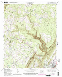
1972 Map of Morgan Springs
USGS Topo · Published 1980About this map
The Cumberland Escarpment dominates the topography of this Tennessee landscape, marking a sharp transition between the upland plateaus and the valley floor where Dayton sits. Settlement patterns follow the high ground along Walden Ridge, where small communities like Summer City and Morgan Springs are established near family landmarks and local institutions. Significant for genealogists, the map identifies numerous small burial sites, including the Old Ogden Cem, Swafford Cem, and Kluka Cem.
Find a feature on this map
68 named features on this map. Tap any name to fly to it.
Don’t see what you’re looking for? This feature index may not catch every label — zoom into the map to look around manually.
Map Details
Editions of this 1972 Morgan Springs Map
3 editions found
Other maps of this area

1886 · Cleveland
USGS Topo · 1:125,000

1887 · Kingston
USGS Topo · 1:125,000

1888 · Chattanooga
USGS Topo · 1:125,000

1891 · Kingston
USGS Topo · 1:125,000

1892 · Pikeville
USGS Topo · 1:125,000

1892 · Cleveland
USGS Topo · 1:125,000

1893 · Chattanooga
USGS Topo · 1:125,000

1893 · Kingston
USGS Topo · 1:125,000

1895 · Cleveland
USGS Topo · 1:125,000

1895 · Pikeville
USGS Topo · 1:125,000