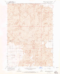
1964 Map of Morgans Pasture NE
USGS Topo · Published 1965About this map
Lava fields dominate this mid-century survey of the Snake River Plain, where the basaltic terrain creates a complex environment for navigation and land use. The topography is defined by the sharp contrast between these volcanic formations and the flatter expanse of Morgans Pasture. The map highlights a critical network of water resources in an otherwise arid landscape, marked by specifically numbered locations such as Well 4816, Well 4842, and Well 4766. A solitary Jeep Trail provides the primary passage through the northern reaches, crossing the boundary between Bonneville Co and Bingham Co. This cartographic record from the early 1960s captures the intersection of geological history and the essential infrastructure required to support life and livestock on the high plains of southeastern Idaho.
Find a feature on this map
12 named features on this map. Tap any name to fly to it.
Don’t see what you’re looking for? This feature index may not catch every label — zoom into the map to look around manually.
Map Details
Editions of this 1964 Morgans Pasture NE Map
This is the sole edition of this map. No revisions or reprints were ever made.
Other maps of this area

1948 · Woodville
USGS Topo · 1:24,000

1949 · Roberts
USGS Topo · 1:62,500

1949 · Shattuck Butte
USGS Topo · 1:24,000

1950 · Shattuck Butte
USGS Topo · 1:24,000

1950 · Woodville
USGS Topo · 1:24,000

1955 · Baldy Knoll
USGS Topo · 1:24,000

1955 · Rose
USGS Topo · 1:24,000

1955 · Firth
USGS Topo · 1:24,000

1955 · Idaho Falls
USGS Topo · 1:250,000

1958 · Idaho Falls
USGS Topo · 1:250,000