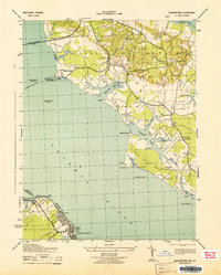
1943 Map of Morgantown
USGS Topo · Published 1943About this map
Colonial Beach and the Maryland shoreline near Morgantown define this maritime landscape during the early 1940s. The map illustrates a region dominated by the wide expanse of the Potomac River and the Wicomico River, where navigation is aided by the Lower Cedar Point Lighthouse and various range lights. On the Maryland side, the landscape is dotted with small rural communities and historic sites such as Old Christ Ch and Shiloh.
Find a feature on this map
63 named features on this map. Tap any name to fly to it.
Don’t see what you’re looking for? This feature index may not catch every label — zoom into the map to look around manually.
Map Details
Editions of this 1943 Morgantown Map
This is the sole edition of this map. No revisions or reprints were ever made.
Other maps of this area

1889 · Fredericksburg
USGS Topo · 1:125,000

1892 · Fredericksburg
USGS Topo · 1:125,000

1892 · Montross
USGS Topo · 1:62,500

1894 · Wicomico
USGS Topo · 1:62,500

1894 · Fredericksburg
USGS Topo · 1:125,000

1895 · Wicomico
USGS Topo · 1:62,500

1895 · Nomini
USGS Topo · 1:125,000

1895 · Montross
USGS Topo · 1:62,500

1898 · Nomini
USGS Topo · 1:125,000

1902 · Wicomico
USGS Topo · 1:62,500