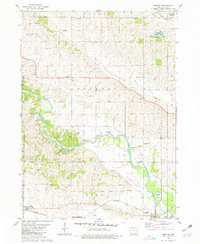
1980 Map of Morley
USGS Topo · Published 1981About this map
The Wapsipinicon River meanders through Jones County in this 1980 survey, defining the landscape between the townships of Jackson, Rome, and Wayne. This river valley is characterized by complex hydrology including features like Cedar Island, Hogs Den Hol, and the sprawling Muskrat Slough State Game Management Area. Human activity is concentrated along the corridors of the Chicago Milwaukee St Paul and Pacific railroad, which serves the small settlements of Morley and Olin.
Find a feature on this map
44 named features on this map. Tap any name to fly to it.
Don’t see what you’re looking for? This feature index may not catch every label — zoom into the map to look around manually.
Map Details
Editions of this 1980 Morley Map
This is the sole edition of this map. No revisions or reprints were ever made.
Other maps of this area

1889 · Tipton
USGS Topo · 1:62,500

1890 · Tipton
USGS Topo · 1:62,500

1890 · Anamosa
USGS Topo · 1:62,500

1891 · Monticello
USGS Topo · 1:62,500

1891 · Mechanicsville
USGS Topo · 1:62,500

1894 · Mechanicsville
USGS Topo · 1:62,500

1900 · Anamosa
USGS Topo · 1:125,000

1901 · Stanwood
USGS Topo · 1:125,000

1958 · Davenport
USGS Topo · 1:250,000

1959 · Dubuque
USGS Topo · 1:250,000