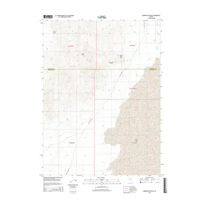
2014 Map of Mormon Dan Peak
USGS Topo · Published 2014About this map
Mormon Dan Peak rises over a landscape defined by the transition from high desert peaks to the alkali flats of the Black Rock Desert. This portion of Nevada, spanning the boundary between Humboldt and Pershing counties, is characterized by vital water sources in an arid environment, such as Mormon Dan Spring, Whiskey Spring, and Barrel Spring. The topographical relief is dominated by the Calico Hills and steep drainages like Mormon Dan Canyon and Copper Canyon. Infrastructure is minimal, limited primarily to the unpaved corridor of Soldier Meadows Rd, which serves as the primary artery through this high-basin terrain. The map's layout reflects the vast, open range management typical of the early 21st century in the Great Basin, where land is organized by the Public Land Survey System as evidenced by various township and range designations.
Find a feature on this map
15 named features on this map. Tap any name to fly to it.
Don’t see what you’re looking for? This feature index may not catch every label — zoom into the map to look around manually.
Map Details
Editions of this 2014 Mormon Dan Peak Map
This is the sole edition of this map. No revisions or reprints were ever made.
Other maps of this area

1886 · Granite Range
USGS Topo · 1:250,000

1889 · Long Valley
USGS Topo · 1:250,000

1894 · Granite Range
USGS Topo · 1:250,000

1954 · Vya
USGS Topo · 1:250,000

1955 · Lovelock
USGS Topo · 1:250,000

1958 · Vya
USGS Topo · 1:250,000

1959 · Lovelock
USGS Topo · 1:250,000

1962 · Vya
USGS Topo · 1:250,000
1979 · Double Hot Springs
USGS Topo · 1:24,000
1980 · Division Peak
USGS Topo · 1:24,000