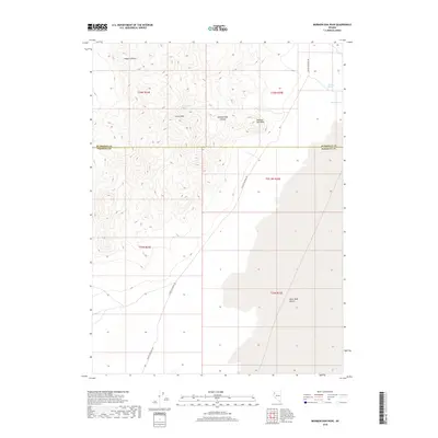
2018 Map of Mormon Dan Peak
USGS Topo · Published 2018About this map
Mormon Dan Peak dominates this high-desert landscape in northern Nevada, situated along the border of Humboldt and Pershing Counties. This arid region is defined by critical water sources such as Whiskey Spring, Barrel Spring, and Mormon Dan Spring, which historically supported movement through the Great Basin. The terrain transitions from the rugged Calico Hills and deep cuts of Mormon Dan Canyon and Copper Canyon into the expansive flatlands of the Black Rock Desert. A primary thoroughfare, Soldier Meadows Rd, traverses the quadrant from north to south, following the base of the mountains. The map illustrates a classic Nevada basin-and-range environment where isolated springs and canyons were the vital focal points for early settlement and ranching ventures in the high desert.
Find a feature on this map
15 named features on this map. Tap any name to fly to it.
Don’t see what you’re looking for? This feature index may not catch every label — zoom into the map to look around manually.
Map Details
Editions of this 2018 Mormon Dan Peak Map
This is the sole edition of this map. No revisions or reprints were ever made.
Other maps of this area

1886 · Granite Range
USGS Topo · 1:250,000

1889 · Long Valley
USGS Topo · 1:250,000

1894 · Granite Range
USGS Topo · 1:250,000

1954 · Vya
USGS Topo · 1:250,000

1955 · Lovelock
USGS Topo · 1:250,000

1958 · Vya
USGS Topo · 1:250,000

1959 · Lovelock
USGS Topo · 1:250,000

1962 · Vya
USGS Topo · 1:250,000
1979 · Double Hot Springs
USGS Topo · 1:24,000
1980 · Division Peak
USGS Topo · 1:24,000