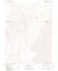
1980 Map of Mormon Dan Peak
USGS Topo · Published 1980About this map
The Calico Hills dominate the western landscape of this northwestern Nevada region, where the rugged terrain drops sharply away toward the expansive alkali flats of the Black Rock Desert to the east. This 1980 survey, based on mid-1970s fieldwork, captures a transition zone between high desert peaks and the basin floor. Settlement is non-existent, defined instead by the sparse water sources critical for survival and livestock in this arid environment, including Mormon Dan Spring and the curiously named Whiskey Spring and Barrel Spring. The boundary between Humboldt and Pershing counties bisects the map horizontally, cutting across Copper Canyon and the slopes of Mormon Dan Peak. A Flowing Well in the south suggests the limited human infrastructure present at the time, providing a clear view of the territory's remote character before late-century changes.
Find a feature on this map
11 named features on this map. Tap any name to fly to it.
Don’t see what you’re looking for? This feature index may not catch every label — zoom into the map to look around manually.
Map Details
Editions of this 1980 Mormon Dan Peak Map
This is the sole edition of this map. No revisions or reprints were ever made.
Other maps of this area

1886 · Granite Range
USGS Topo · 1:250,000

1889 · Long Valley
USGS Topo · 1:250,000

1894 · Granite Range
USGS Topo · 1:250,000

1954 · Vya
USGS Topo · 1:250,000

1955 · Lovelock
USGS Topo · 1:250,000

1958 · Vya
USGS Topo · 1:250,000

1959 · Lovelock
USGS Topo · 1:250,000

1962 · Vya
USGS Topo · 1:250,000
1979 · Double Hot Springs
USGS Topo · 1:24,000
1980 · Division Peak
USGS Topo · 1:24,000