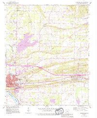
1990 Map of Morrilton East
USGS Topo · Published 1995About this map
The Arkansas River serves as the southern anchor for this landscape, which transitions from the urban center of Morrilton to the timbered hills of Ragsdale Mountain. The map reveals a community deeply rooted in its institutions, from the Childrens Home and County Fairground in the city to the numerous rural churches like Hopewell Ch and Union Hill Ch that dot the countryside. North of the city, the large expanse of Overcup Lake dominates the central topography, surrounded by family-named landmarks and cemeteries such as Scroggin Cem and Gordons Chapel Cem.
Find a feature on this map
51 named features on this map. Tap any name to fly to it.
Don’t see what you’re looking for? This feature index may not catch every label — zoom into the map to look around manually.
Map Details
Editions of this 1990 Morrilton East Map
This is the sole edition of this map. No revisions or reprints were ever made.
Other maps of this area

1889 · Morrilton No. 3
USGS Topo · 1:62,500

1892 · Morrillton
USGS Topo · 1:125,000

1894 · Morrillton
USGS Topo · 1:125,000

1956 · Russellville
USGS Topo · 1:250,000

1961 · Menifee
USGS Topo · 1:24,000

1961 · Perryville
USGS Topo · 1:24,000

1961 · Morrilton East
USGS Topo · 1:24,000

1961 · Morrilton West
USGS Topo · 1:24,000

1961 · Houston
USGS Topo · 1:24,000

1961 · Gleason
USGS Topo · 1:24,000