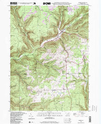
1994 Map of Morris
USGS Topo · Published 1999About this map
Babb Creek carves a deep valley through this heavily forested section of the Allegheny Plateau, where the remote settlements of Morris and Hoytville serve as central points in a landscape dominated by conservation lands. The map details the intersection of Tioga State Forest and multiple state game lands, including State Game Lands No 268 and State Game Lands No 75. Evidence of the region's industrial past is visible in the narrow runs like Tannery Run and the presence of a Mine near Rattler Run. Local history and genealogy are preserved through markers such as Lewis Cem and Parris Elbow Cem, while the high elevation of the surrounding terrain is punctuated by landmarks like Mt Pleasant and the Crawford Fire Tower on the southern ridge.
Find a feature on this map
42 named features on this map. Tap any name to fly to it.
Don’t see what you’re looking for? This feature index may not catch every label — zoom into the map to look around manually.
Map Details
Editions of this 1994 Morris Map
This is the sole edition of this map. No revisions or reprints were ever made.
Other maps of this area

1921 · Trout Run
USGS Topo · 1:62,500

1923 · Trout Run
USGS Topo · 1:62,500

1925 · Blossburg
USGS Topo · 1:62,500

1927 · Blossburg
USGS Topo · 1:62,500

1937 · Waterville
USGS Topo · 1:48,000

1943 · Waterville
USGS Topo · 1:62,500

1944 · Blossburg
USGS Topo · 1:62,500

1944 · Trout Run
USGS Topo · 1:62,500

1946 · Tiadaghton
USGS Topo · 1:24,000

1946 · Antrim
USGS Topo · 1:62,500
Featured Places
- Morris Township, PA
- Duncan Township, PA
- Brown Township, PA
- Pine Township, PA
- Mount Pleasant, Morris Township