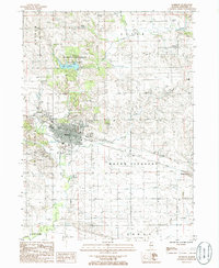
1985 Map of Morrison
USGS Topo · Published 1986About this map
Morrison serves as the central hub of this Whiteside County landscape, showing the town's established grid and local infrastructure in the mid-1980s. To the north, Morrison-Rockwood State Park surrounds Lake Carlton, a significant recreational feature carved into the terrain of Clyde township. The map documents a mix of agricultural utility and mid-century leisure, evidenced by the Drive-In Theater located south of the main settlement and an Inactive Quarry near the town center. Small outlying communities like Malvern, Unionville, Round Grove, and Fenton are clearly marked, alongside numerous small Cem sites that provide valuable reference points for genealogists. Waterways like Rock Creek and French Creek define the drainage patterns of Mount Pleasant and Lyndon, illustrating the relationship between the prairie hydrology and the development of these Illinois townships.
Find a feature on this map
19 named features on this map. Tap any name to fly to it.
Don’t see what you’re looking for? This feature index may not catch every label — zoom into the map to look around manually.
Map Details
Editions of this 1985 Morrison Map
This is the sole edition of this map. No revisions or reprints were ever made.
Other maps of this area

1891 · Clinton
USGS Topo · 1:62,500

1894 · Clinton
USGS Topo · 1:62,500

1899 · Clinton
USGS Topo · 1:125,000

1932 · Prophetstown
USGS Topo · 1:48,000

1934 · Morrison
USGS Topo · 1:48,000

1936 · Prophetstown
USGS Topo · 1:62,500

1940 · Morrison
USGS Topo · 1:62,500

1952 · Erie
USGS Topo · 1:62,500

1952 · Clinton
USGS Topo · 1:62,500

1958 · Davenport
USGS Topo · 1:250,000