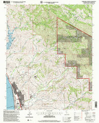
1995 Map of Morro Bay North
USGS Topo · Published 2000About this map
The northern reaches of Morro Bay meet the coastal foothills in this mid-1990s survey, illustrating the intersection of residential expansion and protected wilderness. The urban grid, defined by streets like Ironwood Ave and Main St, transitions into the vast Los Padres National Forest and the historical boundaries of the San Bernardo (Cane) Grant Bdy. Significant infrastructure for the growing community is evident, including the Whale Rock Reservoir and multiple Quarry and Gravel Pit operations that suggest local resource extraction. Educational and recreational life is anchored by Del Mar School, the local High Sch, and the waterfront Atascadero State Beach. The landscape is deeply etched by a network of drainage systems, such as Toro Creek and Little Morro Creek, which flow toward the Pacific Ocean from peaks like Rusty Peak.
Find a feature on this map
42 named features on this map. Tap any name to fly to it.
Don’t see what you’re looking for? This feature index may not catch every label — zoom into the map to look around manually.
Map Details
Editions of this 1995 Morro Bay North Map
This is the sole edition of this map. No revisions or reprints were ever made.
Other maps of this area

1897 · San Luis Obispo
USGS Topo · 1:62,500

1897 · Cayucos
USGS Topo · 1:62,500

1900 · San Luis
USGS Topo · 1:125,000

1919 · Paso Robles
USGS Topo · 1:62,500

1919 · Adelaida
USGS Topo · 1:62,500

1932 · Adelaida
USGS Topo · 1:62,500

1937 · Cayucos
USGS Topo · 1:62,500

1942 · Adelaida
USGS Topo · 1:62,500

1942 · San Luis Obispo
USGS Topo · 1:62,500

1943 · Paso Robles
USGS Topo · 1:62,500