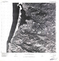
1976 Map of Morro Bay South
USGS Topo · Published 1979About this map
Morro Rock stands as a prominent sentinel at the entrance to the harbor, anchoring this 1976 orthophotoquad of the Central California coast. This aerial perspective, captured in cooperation with the Soil Conservation Service, reveals the mid-seventies footprint of Morro Bay as it extends southward toward the newer residential developments of Baywood Park and Los Osos. The imagery provides a clear view of the complex estuarine environment and the shifting sand spits that buffer the bay from the Pacific Ocean. Researchers can observe the transition from urbanized street grids to the surrounding agricultural and open lands, documenting the land-use patterns of San Luis Obispo County just before the rapid growth of the late twentieth century.
Find a feature on this map
5 named features on this map. Tap any name to fly to it.
Don’t see what you’re looking for? This feature index may not catch every label — zoom into the map to look around manually.
Map Details
Editions of this 1976 Morro Bay South Map
This is the sole edition of this map. No revisions or reprints were ever made.
Other maps of this area

1897 · Port Harford
USGS Topo · 1:62,500

1897 · San Luis Obispo
USGS Topo · 1:62,500

1897 · Cayucos
USGS Topo · 1:62,500

1897 · Arroyo Grande
USGS Topo · 1:62,500

1900 · San Luis
USGS Topo · 1:125,000

1937 · Cayucos
USGS Topo · 1:62,500

1941 · Port San Luis
USGS Topo · 1:62,500

1942 · San Luis Obispo
USGS Topo · 1:62,500

1942 · Arroyo Grande
USGS Topo · 1:62,500

1943 · Cayucos
USGS Topo · 1:62,500