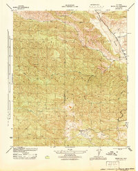
1944 Map of Morro Hill
USGS Topo · Published 1944About this map
Potrero Seco Guard Sta sits atop a high plateau in the heart of the Los Padres National Forest, serving as a central outpost for this remote mountain landscape during the early 1940s. The terrain is defined by a complex network of canyons and peaks, where the Santa Barbara Ventura county line traverses the high ridges. In the northeast, the Cuyama River creates a wide wash as it flows past the small mountain community of Potrero Seco and the Apache School, providing one of the few points of access and education in this wilderness area.
Find a feature on this map
21 named features on this map. Tap any name to fly to it.
Don’t see what you’re looking for? This feature index may not catch every label — zoom into the map to look around manually.
Map Details
Editions of this 1944 Morro Hill Map
This is the sole edition of this map. No revisions or reprints were ever made.
Other maps of this area

1893 · Oceanside
USGS Topo · 1:62,500

1893 · Escondido
USGS Topo · 1:62,500

1898 · Oceanside
USGS Topo · 1:62,500

1901 · Escondido
USGS Topo · 1:62,500

1901 · Oceanside
USGS Topo · 1:62,500

1901 · San Luis Rey
USGS Topo · 1:125,000

1904 · Southern California Sheet No. 2
USGS Topo · 1:250,000

1941 · Margarita Peak
USGS Topo · 1:62,500

1942 · Margarita Peak
USGS Topo · 1:62,500

1942 · Temecula
USGS Topo · 1:62,500
Featured Places
- Oceanside, CA
- Marine Corps Base Camp Pendleton, CA
- Jofegan, Marine Corps Base Camp Pendleton
- San Diego County, CA
- United States