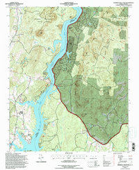
1994 Map of Morrow Mountain
USGS Topo · Published 1996About this map
Morrow Mountain State Park and the Uwharrie National Forest dominate this landscape along the Stanly and Montgomery county line. This 1994 revision reflects the modern character of the area, where the impounded waters of the Lake Tillery Pee Dee River have created a corridor for residential developments like Woodrun, Sugarloaf Shores, and Emerald Shores. The rugged topography is punctuated by numerous named peaks including Sugarloaf Mtn, Mill Mtn, and Tater Top Mtn.
Find a feature on this map
44 named features on this map. Tap any name to fly to it.
Don’t see what you’re looking for? This feature index may not catch every label — zoom into the map to look around manually.
Map Details
Editions of this 1994 Morrow Mountain Map
This is the sole edition of this map. No revisions or reprints were ever made.
Other maps of this area

1942 · Troy
USGS Topo · 1:125,000

1953 · Raleigh
USGS Topo · 1:250,000

1953 · Charlotte
USGS Topo · 1:250,000

1954 · Charlotte
USGS Topo · 1:250,000

1954 · Raleigh
USGS Topo · 1:250,000

1956 · Mount Gilead East
USGS Topo · 1:24,000

1956 · Mount Gilead West
USGS Topo · 1:24,000

1957 · Albemarle
USGS Topo · 1:62,500

1957 · Troy
USGS Topo · 1:62,500

1960 · Charlotte
USGS Topo · 1:250,000