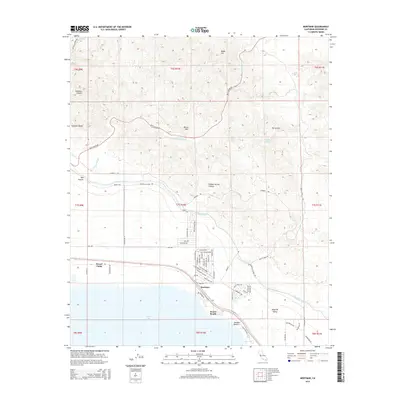
2015 Map of Mortmar
USGS Topo · Published 2015About this map
The Salton Sea shoreline meets the arid uplift of the Mecca Hills in this detailed survey of the southern California desert. Near the water, small residential pockets like Mortmar, Desert Beach, and Sneaker Beach are organized along a dense grid of streets including Coral Reef Rd and Via Costa Brava, illustrating the area's mid-century recreational development. Just inland, the Coachella Canal cuts across the landscape, a vital artery of water infrastructure paralleled by Coachella Canal Rd. To the north, the topography transitions into a complex system of canyons and peaks. This rugged sector includes Hidden Spring Canyon, the narrow passage of Skeleton Canyon, and geologic features like The Grotto and Blake Hill. The map also identifies remote water sources such as Sheep Hole Oasis and Hidden Spring, which provide critical reference points within the surrounding desert terrain.
Find a feature on this map
73 named features on this map. Tap any name to fly to it.
Don’t see what you’re looking for? This feature index may not catch every label — zoom into the map to look around manually.
Map Details
Editions of this 2015 Mortmar Map
This is the sole edition of this map. No revisions or reprints were ever made.
Other maps of this area

1904 · Indio
USGS Topo · 1:125,000

1931 · Vallecito
USGS Topo · 1:125,000

1940 · Cottonwood Spring
USGS Topo · 1:62,500

1940 · Durmid
USGS Topo · 1:62,500

1941 · Coachella
USGS Topo · 1:62,500

1942 · Agua Dulce
USGS Topo · 1:62,500

1943 · Vallecito
USGS Topo · 1:125,000

1943 · Coachella
USGS Topo · 1:62,500

1944 · Agua Dulce
USGS Topo · 1:62,500

1944 · Cottonwood Spring
USGS Topo · 1:62,500