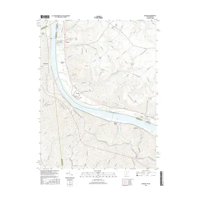
2016 Map of Moscow
USGS Topo · Published 2016About this map
The Ohio River carves a deep valley through this borderland, separating the highlands of Clermont County, Ohio, from the riverfront bluffs of Campbell and Bracken Counties in Kentucky. Along the northern bank, the historic river towns of Moscow, Neville, and Chilo follow the shoreline, linked by a network of steep valley runs including Roy Run, Maple Creek, and Bear Creek. The rugged interior is defined by ridge-top settlements such as Fruit Ridge and Eden Ridge, where narrow roads wind through deep draws like Opossum Hollow. This survey provides significant detail for genealogists, documenting numerous small burial grounds that dot the landscape, including Vesper Cemetery and Woods Hill Cemetery. Across the water, the Kentucky side features the community of Ivor and the settlement of Bradford, tucked between the river and the sharp rises of the Kentucky hills.
Find a feature on this map
103 named features on this map. Tap any name to fly to it.
Don’t see what you’re looking for? This feature index may not catch every label — zoom into the map to look around manually.
Map Details
Editions of this 2016 Moscow Map
This is the sole edition of this map. No revisions or reprints were ever made.
Other maps of this area

1929 · Alexandria
USGS Topo · 1:48,000

1930 · Falmouth
USGS Topo · 1:48,000

1931 · Felicity
USGS Topo · 1:62,500

1936 · Alexandria
USGS Topo · 1:62,500

1936 · Falmouth
USGS Topo · 1:62,500

1952 · Berlin
USGS Topo · 1:24,000

1952 · Brooksville
USGS Topo · 1:24,000

1953 · Laurel
USGS Topo · 1:24,000

1953 · Bethel
USGS Topo · 1:24,000

1953 · Butler
USGS Topo · 1:24,000