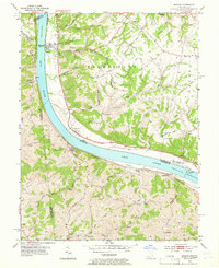
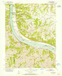
1953 Map of Moscow
USGS Topo · Published 1966About this map
The Ohio River carves a deep valley through the borderlands of Ohio and Kentucky, anchoring the small riverfront communities of Moscow and Neville. This mid-century landscape is defined by the industrial and transport infrastructure of the river, notably featuring Lock and Dam No 34 near Chilo Cemetery. Steep ridges such as Fruit Ridge and Eden Ridge rise sharply from the water, separated by drainages like Maple Creek and Bear Creek. The Chesapeake and Ohio railroad tracks trace the Kentucky bank, serving settlements like Carntown and Foster. Local heritage is preserved in numerous rural landmarks, from the Flat Rock Ch on the heights to the Cemetery Chapel in the south. The road network, including the Ohio Valley Pike, follows the natural contours of the dissected plateau, connecting isolated homesteads and family cemeteries.
Find a feature on this map
47 named features on this map. Tap any name to fly to it.
Don’t see what you’re looking for? This feature index may not catch every label — zoom into the map to look around manually.
Map Details
Editions of this 1953 Moscow Map
2 editions found
Other maps of this area

1929 · Alexandria
USGS Topo · 1:48,000

1930 · Falmouth
USGS Topo · 1:48,000

1931 · Felicity
USGS Topo · 1:62,500

1936 · Alexandria
USGS Topo · 1:62,500

1936 · Falmouth
USGS Topo · 1:62,500

1952 · Berlin
USGS Topo · 1:24,000

1952 · Brooksville
USGS Topo · 1:24,000

1953 · Laurel
USGS Topo · 1:24,000

1953 · Bethel
USGS Topo · 1:24,000

1953 · Butler
USGS Topo · 1:24,000