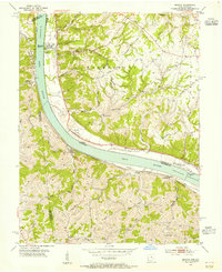
1953 Map of Moscow
USGS Topo · Published 1955About this map
The Ohio River carves a sweeping arc through this mid-century landscape, serving as a political and industrial boundary between Clermont County, Ohio, and the Kentucky counties of Campbell, Pendleton, and Bracken. Along the northern bank, the settlements of Moscow, Neville, and Chilo follow the river road, while Chesapeake and Ohio rail lines hug the southern shore near Bradford and Foster. The terrain is defined by deeply incised hollows like Oppossum Hollow and prominent elevations such as Fruit Ridge and Bolender Ridge.
Find a feature on this map
53 named features on this map. Tap any name to fly to it.
Don’t see what you’re looking for? This feature index may not catch every label — zoom into the map to look around manually.
Map Details
Editions of this 1953 Moscow Map
2 editions found
Other maps of this area

1929 · Alexandria
USGS Topo · 1:48,000

1930 · Falmouth
USGS Topo · 1:48,000

1931 · Felicity
USGS Topo · 1:62,500

1936 · Alexandria
USGS Topo · 1:62,500

1936 · Falmouth
USGS Topo · 1:62,500

1952 · Berlin
USGS Topo · 1:24,000

1952 · Brooksville
USGS Topo · 1:24,000

1953 · Laurel
USGS Topo · 1:24,000

1953 · Bethel
USGS Topo · 1:24,000

1953 · Butler
USGS Topo · 1:24,000