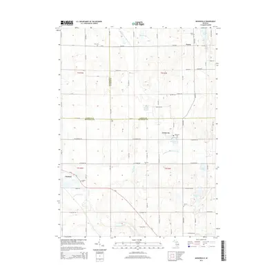
2014 Map of Mosherville
USGS Topo · Published 2014About this map
The South Branch Kalamazoo River and the Saint Joseph River headwaters converge in this agricultural region at the junction of Jackson, Hillsdale, and Calhoun counties. The small settlement of Pulaski anchors the northern portion of the quadrangle, while Mosherville sits just south of the county line along the river's path. This landscape is defined by its deep genealogical roots, evidenced by numerous burial grounds such as Fisher Cem, Buck Cem, and King Cem that dot the section lines.
Find a feature on this map
72 named features on this map. Tap any name to fly to it.
Don’t see what you’re looking for? This feature index may not catch every label — zoom into the map to look around manually.
Map Details
Editions of this 2014 Mosherville Map
This is the sole edition of this map. No revisions or reprints were ever made.
Other maps of this area

1948 · Spring Arbor
USGS Topo · 1:62,500

1948 · Homer
USGS Topo · 1:62,500

1949 · Homer
USGS Topo · 1:62,500

1949 · Spring Arbor
USGS Topo · 1:62,500

1953 · Fort Wayne
USGS Topo · 1:250,000

1956 · Fort Wayne
USGS Topo · 1:250,000

1958 · Grand Rapids
USGS Topo · 1:250,000

1959 · Hillsdale
USGS Topo · 1:24,000

1959 · North Adams
USGS Topo · 1:24,000
1960 · Allen
USGS Topo · 1:24,000