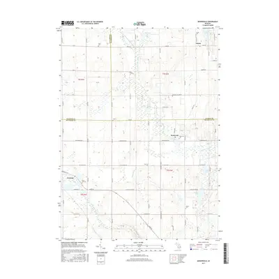
2017 Map of Mosherville
USGS Topo · Published 2017About this map
Pulaski and Mosherville anchor this rural landscape where the headwaters of major Michigan river systems begin their descent. The South Branch Kalamazoo River and S Br Kalamazoo River wind through the eastern half of the township, while the Saint Joseph River appears in the southwestern corner. This area serves as a significant drainage divide, marked by a high concentration of small kettle lakes and wetlands including Goose Lake, Mosherville Lake, and Hastings Lake. For genealogists, the map is particularly dense with historic burial sites, featuring eight distinct cemeteries such as Fisher Cem, King Cem, Case Cem, and Johnson Cem. The village of Litchfield sits at the western edge, surrounded by a grid of rural routes like Folks Rd and Homer Rd that define the agricultural character of Jackson, Hillsdale, and Calhoun counties.
Find a feature on this map
71 named features on this map. Tap any name to fly to it.
Don’t see what you’re looking for? This feature index may not catch every label — zoom into the map to look around manually.
Map Details
Editions of this 2017 Mosherville Map
This is the sole edition of this map. No revisions or reprints were ever made.
Other maps of this area

1948 · Spring Arbor
USGS Topo · 1:62,500

1948 · Homer
USGS Topo · 1:62,500

1949 · Homer
USGS Topo · 1:62,500

1949 · Spring Arbor
USGS Topo · 1:62,500

1953 · Fort Wayne
USGS Topo · 1:250,000

1956 · Fort Wayne
USGS Topo · 1:250,000

1958 · Grand Rapids
USGS Topo · 1:250,000

1959 · Hillsdale
USGS Topo · 1:24,000

1959 · North Adams
USGS Topo · 1:24,000
1960 · Allen
USGS Topo · 1:24,000