
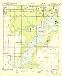
1935 Map of Moss Bluff
USGS Topo · Published 1935About this map
The Calcasieu River dominates this mid-1930s landscape north of Lake Charles, winding through a complex system of marshes and bayous. This area shows a critical transition from river-dependent transportation to modern rail and road networks, evidenced by the numerous ferry crossings such as Southerland Ferry and Perkins Ferry situated near the newer Southern Pacific rail line. Small settlements like Newton, Ararat, and Moss Bluff are scattered across the central plains, while more remote industrial sites like Moser Mill sit further north. The map documents the intricate hydrology of the region, specifically how English Bayou and the West Fork Calcasieu River interact with the larger main channel. For those tracking family history, the inclusion of Ritchie Cem and established hamlets like Gillis and Belfield provide precise locations for ancestral homesteads during this period of coastal Louisiana development.
Find a feature on this map
37 named features on this map. Tap any name to fly to it.
Don’t see what you’re looking for? This feature index may not catch every label — zoom into the map to look around manually.
Map Details
Editions of this 1935 Moss Bluff Map
This is the sole edition of this map. No revisions or reprints were ever made.
Other maps of this area

1932 · Lake Charles NE
USGS Topo · 1:31,680

1932 · Lake Charles NW
USGS Topo · 1:31,680

1935 · Buhler
USGS Topo · 1:31,680

1935 · Gordon
USGS Topo · 1:31,680

1935 · Gaytine
USGS Topo · 1:31,680

1942 · Lake Charles
USGS Topo · 1:62,500

1947 · Gaytine
USGS Topo · 1:31,680

1947 · Moss Bluff
USGS Topo · 1:31,680

1947 · Hecker
USGS Topo · 1:31,680
1947 · West Lake
USGS Topo · 1:31,680