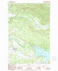
1987 Map of Mossyrock
USGS Topo · Published 1987About this map
Mossyrock and the nearby settlement of Ajlune are central to this landscape shaped by the managed waters of the Cowlitz River. By the late 1980s, the geography here was defined by the massive reservoirs of Riffe Lake and Mayfield Lake, separated by the Mossyrock Dam Spillway. This industrial infrastructure stands alongside older rural markers, including a local Cem and the Swofford Valley to the southeast. To the north, the terrain rises into the Snoqualmie National Forest, where the Tilton River meanders toward the village of Bremer. The map reveals a transition from the agricultural and residential pockets near Harmony to the timber-covered slopes of Bremer Mountain, illustrating how hydroelectric development and forestry have layered over the original river valley communities.
Find a feature on this map
36 named features on this map. Tap any name to fly to it.
Don’t see what you’re looking for? This feature index may not catch every label — zoom into the map to look around manually.
Map Details
Editions of this 1987 Mossyrock Map
2 editions found
Other maps of this area

1916 · Chehalis
USGS Topo · 1:125,000

1919 · Mount St Helens
USGS Topo · 1:125,000

1937 · Eatonville
USGS Topo · 1:125,000

1942 · Toutle
USGS Topo · 1:62,500

1943 · Willapa
USGS Topo · 1:62,500

1953 · Hoquiam
USGS Topo · 1:250,000

1953 · Toutle
USGS Topo · 1:62,500

1953 · Elk Rock
USGS Topo · 1:62,500

1954 · Onalaska
USGS Topo · 1:62,500

1957 · Hoquiam
USGS Topo · 1:250,000