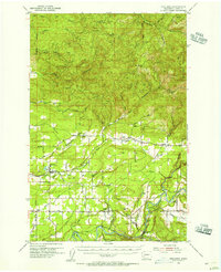
1954 Map of Onalaska
USGS Topo · Published 1956About this map
Onalaska stands at the heart of this Lewis County landscape, serving as a hub for the Cowlitz and Chehalis Railway as it winds through the river valleys. The 1950s terrain is defined by the complex drainage system of the North Fork Newaukum River, Middle Fork Newaukum River, and South Fork Newaukum River, which converge toward the west. Settlement is concentrated along these watercourses and the Cascade Highway, featuring small communities like Silver Creek, Salkum, and Cinebar. To the north, the elevation rises toward Windy Knob and the Snoqualmie National Forest, while the southern reaches follow the Cowlitz River near Mayfield. Genealogists will find the Alpha Cem and several unnamed cemeteries, alongside rural markers such as the High Sch in Onalaska and the State Fish Hatchery along the Tilton River.
Find a feature on this map
42 named features on this map. Tap any name to fly to it.
Don’t see what you’re looking for? This feature index may not catch every label — zoom into the map to look around manually.
Map Details
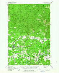
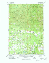
Editions of this 1954 Onalaska Map
3 editions found
Other maps of this area

1916 · Chehalis
USGS Topo · 1:125,000

1919 · Mount St Helens
USGS Topo · 1:125,000

1937 · Eatonville
USGS Topo · 1:125,000

1940 · Tenino
USGS Topo · 1:62,500

1941 · Olequa
USGS Topo · 1:62,500

1941 · Tanwax Lake
USGS Topo · 1:62,500

1942 · Toutle
USGS Topo · 1:62,500

1943 · Willapa
USGS Topo · 1:62,500

1944 · Tenino
USGS Topo · 1:62,500

1944 · Yelm
USGS Topo · 1:62,500