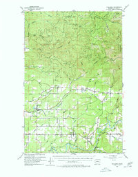
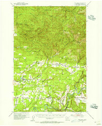
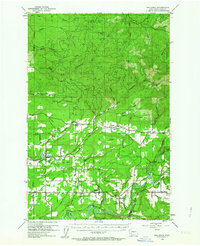
1954 Map of Onalaska
USGS Topo · Published 1978About this map
The Cowlitz Chehalis and Cascade Railroad defines the industrial corridor of this mid-century Lewis County landscape, connecting the timber-heavy highlands of the Snoqualmie National Forest with lowland milling centers. The settlement of Onalaska stands as a primary hub, featuring a local High Sch and organized street grid typical of a thriving company town. To the south, the Cowlitz River carves a broad valley through the Cowlitz Prairie, where agricultural clearings at Ethel and Mayfield contrast with the dense drainage networks of the Skookumchuck River in the north.
Find a feature on this map
56 named features on this map. Tap any name to fly to it.
Don’t see what you’re looking for? This feature index may not catch every label — zoom into the map to look around manually.
Map Details
Editions of this 1954 Onalaska Map
3 editions found
Other maps of this area

1916 · Chehalis
USGS Topo · 1:125,000

1919 · Mount St Helens
USGS Topo · 1:125,000

1937 · Eatonville
USGS Topo · 1:125,000

1940 · Tenino
USGS Topo · 1:62,500

1941 · Olequa
USGS Topo · 1:62,500

1941 · Tanwax Lake
USGS Topo · 1:62,500

1942 · Toutle
USGS Topo · 1:62,500

1943 · Willapa
USGS Topo · 1:62,500

1944 · Tenino
USGS Topo · 1:62,500

1944 · Yelm
USGS Topo · 1:62,500