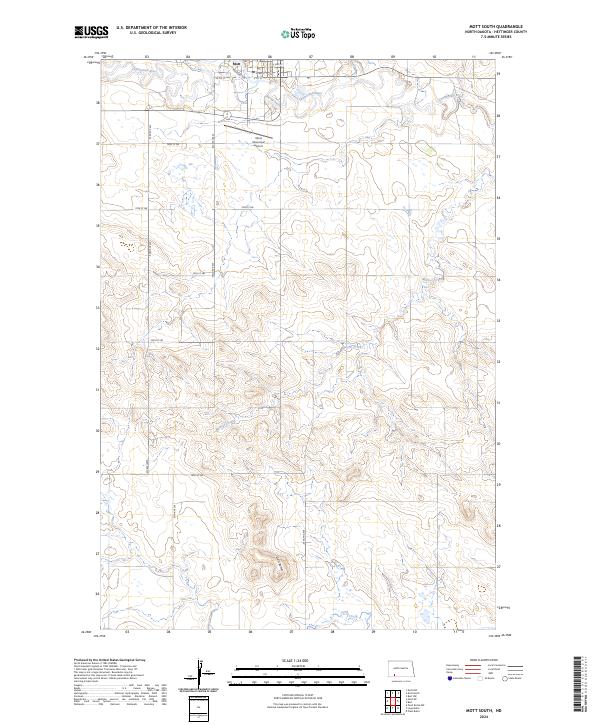
2024 Map of Mott South
USGS Topo · Published 2024About this map
The Mott townsite sits at the northern edge of this high-plains landscape, where the Cannonball River meanders through the Missouri Plateau. This modern survey illustrates the enduring township and range grid, documented through lines like t134n r93w, which shapes the agricultural land and road network south of the city. Notable landmarks include the Mott Municipal Airport and the distinct elevation of Gert Buttes in the south, which provides a natural break in the terrain. The hydrological pattern is defined by several seasonal watercourses, including Mehrer Creek and Timber Creek, which cut across the prairie. Residential and industrial layouts in the north are captured through streets such as Railroad Ave and Illinois Ave, reflecting the community's historical connection to transportation corridors.
Find a feature on this map
25 named features on this map. Tap any name to fly to it.
Don’t see what you’re looking for? This feature index may not catch every label — zoom into the map to look around manually.
Map Details
Editions of this 2024 Mott South Map
This is the sole edition of this map. No revisions or reprints were ever made.
Other maps of this area

1953 · Dickinson
USGS Topo · 1:250,000

1957 · Dickinson
USGS Topo · 1:250,000

1966 · Mott South
USGS Topo · 1:24,000

1966 · Mott NW
USGS Topo · 1:24,000

1966 · Mott SW
USGS Topo · 1:24,000

1966 · Mott North
USGS Topo · 1:24,000

1969 · Burt
USGS Topo · 1:24,000
1969 · Burt NW
USGS Topo · 1:24,000

1974 · Pearl Butte NW
USGS Topo · 1:24,000

1974 · Long Butte
USGS Topo · 1:24,000