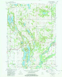
1981 Map of Mottville
USGS Topo · Published 1982About this map
The St Joseph River and Pigeon River converge near the settlement of Mottville, highlighting a landscape shaped by glacial water and early Midwestern transit. This early 1980s survey illustrates a region defined by its numerous lakes and varied agricultural development along the Michigan and Indiana border. Notable community centers such as Union and Williamsville appear alongside legacy landmarks like the Baldwin Prairie Sch and Chapel Hill Ch.
Find a feature on this map
75 named features on this map. Tap any name to fly to it.
Don’t see what you’re looking for? This feature index may not catch every label — zoom into the map to look around manually.
Map Details
Editions of this 1981 Mottville Map
This is the sole edition of this map. No revisions or reprints were ever made.
Other maps of this area

1914 · Three Rivers
USGS Topo · 1:62,500

1916 · Three Rivers
USGS Topo · 1:62,500

1943 · Three Rivers
USGS Topo · 1:62,500

1948 · Vandalia
USGS Topo · 1:62,500

1949 · Vandalia
USGS Topo · 1:62,500

1953 · Fort Wayne
USGS Topo · 1:250,000

1956 · Fort Wayne
USGS Topo · 1:250,000
1961 · Bristol
USGS Topo · 1:24,000
1961 · Middlebury
USGS Topo · 1:24,000
1961 · Elkhart
USGS Topo · 1:24,000