
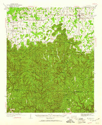
1936 Map of Moulton
USGS Topo · Published 1936About this map
Moulton serves as the regional anchor in this 1930s survey, marking a landscape defined by the transition from upland agricultural plains to the densely ridged terrain of the Black Warrior National Forest. The map captures a sophisticated network of early transit corridors like the Byler Road and Goodlett Road, which connect a series of small, dispersed settlements including Landersville and Needmore.
Find a feature on this map
97 named features on this map. Tap any name to fly to it.
Don’t see what you’re looking for? This feature index may not catch every label — zoom into the map to look around manually.
Map Details
Editions of this 1936 Moulton Map
2 editions found
Other maps of this area

1924 · Tuscumbia
USGS Topo · 1:48,000

1926 · Tuscumbia
USGS Topo · 1:62,500

1935 · Moulton
USGS Topo · 1:24,000

1935 · Upshaw
USGS Topo · 1:24,000

1935 · Danville
USGS Topo · 1:48,000

1935 · Oakville
USGS Topo · 1:24,000

1936 · Newburg
USGS Topo · 1:24,000

1936 · Delmar
USGS Topo · 1:24,000

1936 · Kinlock Spring
USGS Topo · 1:24,000

1936 · Caddo
USGS Topo · 1:24,000