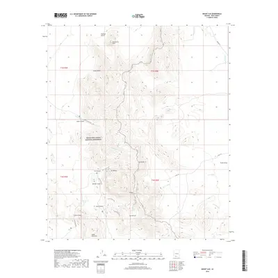
2018 Map of Mount Ajo
USGS Topo · Published 2018About this map
Organ Pipe Cactus National Monument dominates this desert landscape, where the Ajo Range and Diablo Mountains form a dramatic high-relief boundary. This 2018 survey documents a remote wilderness defined by seasonal hydrology and significant geological landmarks. Notable features include the prominent Montezuma Head and Mt Ajo, the highest point in the monument. The map traces the intricate drainage patterns of Alamo Wash, Gu Vo Wash, and Pia Oik Wash, while permanent and semi-permanent water sources like Bull Pasture Spring and Wild Horse Tank indicate the vital lifeblood of this arid environment. A network of primitive paths, such as the Alamo Canyon Trail and Bull Pasture Trail, provides the primary means of navigating the steep canyons and washes like Arch Canyon and Canyon Diablo.
Find a feature on this map
32 named features on this map. Tap any name to fly to it.
Don’t see what you’re looking for? This feature index may not catch every label — zoom into the map to look around manually.
Map Details
Editions of this 2018 Mount Ajo Map
This is the sole edition of this map. No revisions or reprints were ever made.
Other maps of this area

1953 · Ajo
USGS Topo · 1:250,000

1954 · Sonoyta
USGS Topo · 1:250,000

1957 · Ajo
USGS Topo · 1:250,000

1958 · Ajo
USGS Topo · 1:250,000

1962 · Ajo
USGS Topo · 1:250,000

1963 · Ajo
USGS Topo · 1:250,000

1963 · Mt. Ajo
USGS Topo · 1:62,500

1963 · Lukeville
USGS Topo · 1:62,500

1963 · Kino Peak
USGS Topo · 1:62,500

1963 · Lukeville
USGS Topo · 1:250,000