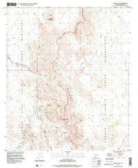
1996 Map of Mount Ajo
USGS Topo · Published 2000About this map
Mount Ajo towers over this section of the Sonoran Desert, where the rugged peaks of the Ajo Range separate the Organ Pipe Cactus National Monument from the Tohono O'odham Indian Reservation to the east. The topography is defined by a series of dramatic drainages including Arch Canyon, Estes Canyon, and the three forks of Alamo Canyon, which descend toward the Alamo Road. Traces of human activity are centered around vital water sources such as Bull Pasture Spring and Barajita Well, reflecting the historical importance of these spots in an arid landscape. To the north, the distinctive landmark of Montezumas Head (I'itoi Mo'o) stands near Pitahaya Canyon, while the southern reaches feature the Diablo Mountains and the loop of Ajo Mountain Drive, providing a detailed look at the intersection of protected wilderness and indigenous lands during the late 1990s.
Find a feature on this map
30 named features on this map. Tap any name to fly to it.
Don’t see what you’re looking for? This feature index may not catch every label — zoom into the map to look around manually.
Map Details
Editions of this 1996 Mount Ajo Map
This is the sole edition of this map. No revisions or reprints were ever made.
Other maps of this area

1953 · Ajo
USGS Topo · 1:250,000

1954 · Sonoyta
USGS Topo · 1:250,000

1957 · Ajo
USGS Topo · 1:250,000

1958 · Ajo
USGS Topo · 1:250,000

1962 · Ajo
USGS Topo · 1:250,000

1963 · Ajo
USGS Topo · 1:250,000

1963 · Mt. Ajo
USGS Topo · 1:62,500

1963 · Lukeville
USGS Topo · 1:62,500

1963 · Kino Peak
USGS Topo · 1:62,500

1963 · Lukeville
USGS Topo · 1:250,000