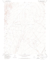
1980 Map of Mount Annie NE
USGS Topo · Published 1980About this map
The Monte Cristo Mountains dominate the western edge of this Nevada landscape, descending into the broad expanse of Gabbs Valley. This arid basin in Nye County is defined by its drainage systems, including Phillips Wash and Gabbs Wash, which pattern the valley floor. Evidence of resource exploration and infrastructure is visible through a prominent Pipeline and several locations marked simply as Prospect, indicating the mineral interests that have long drawn attention to this remote section of the Great Basin.
Find a feature on this map
9 named features on this map. Tap any name to fly to it.
Don’t see what you’re looking for? This feature index may not catch every label — zoom into the map to look around manually.
Map Details
Editions of this 1980 Mount Annie NE Map
This is the sole edition of this map. No revisions or reprints were ever made.
Other maps of this area

1907 · Tonopah
USGS Topo · 1:250,000

1908 · Tonopah
USGS Topo · 1:250,000

1908 · Carson Sink
USGS Topo · 1:250,000

1909 · Hawthorne
USGS Topo · 1:250,000

1910 · Carson Sink
USGS Topo · 1:250,000

1911 · Hawthorne
USGS Topo · 1:250,000

1915 · Hawthorne
USGS Topo · 1:250,000

1948 · Paradise Peak
USGS Topo · 1:62,500

1948 · Walker Lake
USGS Topo · 1:250,000

1950 · Paradise Peak
USGS Topo · 1:62,500