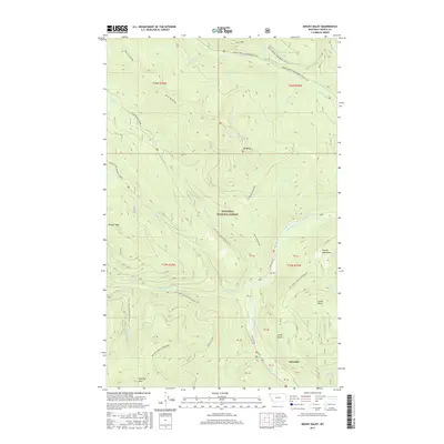
2017 Map of Mount Baldy
USGS Topo · Published 2017About this map
Sylvanite sits along the Yaak River in this portion of the Kotenai National Forest, where steep timbered slopes define the western edge of the Purcell Mountains. The landscape is dominated by high peaks including Mt Baldy, Thunder Mtn, and Red Top Mountain. A complex network of Forest Service roads, such as Natl Forest Develop Road 591 Rd, provides access to these high elevations and remote drainages. The drainage patterns are intricate, with Hellroaring Cr, Spread Cr, and Meadow Cr carving deep valleys through the terrain. Evidence of winter recreation is found in the northern reaches, where the Spread Creek Snowmobile (Snow) and Beetle Creek Snowmobile (Snow) routes follow the high ridges, illustrating how the mountain geography dictates seasonal land use in this corner of Lincoln County.
Find a feature on this map
47 named features on this map. Tap any name to fly to it.
Don’t see what you’re looking for? This feature index may not catch every label — zoom into the map to look around manually.
Map Details
Editions of this 2017 Mount Baldy Map
This is the sole edition of this map. No revisions or reprints were ever made.
Other maps of this area

1911 · Priest Lake
USGS Topo · 1:250,000

1913 · Priest Lake
USGS Topo · 1:250,000

1957 · Kalispell
USGS Topo · 1:250,000

1958 · Sandpoint
USGS Topo · 1:250,000

1960 · Kalispell
USGS Topo · 1:250,000

1961 · Kalispell
USGS Topo · 1:250,000

1963 · Sandpoint
USGS Topo · 1:250,000

1963 · Sylvanite
USGS Topo · 1:24,000

1963 · Mount Baldy
USGS Topo · 1:24,000

1963 · Northwest Peak
USGS Topo · 1:24,000