
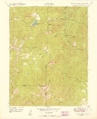
1949 Map of Mount Big Chief
USGS Topo · Published 1949About this map
Rosemont and the surrounding high-altitude terrain of the Pike National Forest are documented here in detail shortly after World War II. The landscape is defined by its recreation and ranching character, centered on the Penrose-Rosemont Reservoir and the Broadmoor Lodge. This era shows a network of mountain roads and trails, including the Gold Camp Road and the Cheyenne Mtn Trail, providing access to remote locations like the Emerald Valley Boys Camp and Emerald Valley Ranch.
Find a feature on this map
43 named features on this map. Tap any name to fly to it.
Don’t see what you’re looking for? This feature index may not catch every label — zoom into the map to look around manually.
Map Details
Editions of this 1949 Mount Big Chief Map
This is the sole edition of this map. No revisions or reprints were ever made.
Other maps of this area

1893 · Colorado Springs
USGS Topo · 1:125,000

1894 · Pikes Peak
USGS Topo · 1:125,000

1901 · Pikes Peak
USGS Topo · 1:125,000

1901 · Pikes Peak
USGS Topo · 1:62,500

1909 · Colorado Springs
USGS Topo · 1:125,000

1942 · Colorado Springs
USGS Topo · 1:125,000
1948 · Mount Big Chief
USGS Topo · 1:24,000

1948 · Mount Pittsburg
USGS Topo · 1:24,000

1948 · Timber Mountain
USGS Topo · 1:24,000
1948 · Manitou Springs
USGS Topo · 1:24,000