
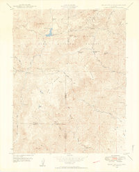
1948 Map of Mount Big Chief
USGS Topo · Published 1953About this map
Gold Camp Road winds through the high elevations of the Pike National Forest, tracing a route past mountain landmarks and early 20th-century retreats. This 1948 survey shows a landscape of scattered lodges and ranching outposts, including Broadmoor Lodge and the Rosemont settlement situated near the Penrose-Rosemont Reservoir. The mapping captures the transition from active extraction to recreation, noting an Abandoned Mine near Sugarloaf Mountain alongside the Emerald Valley Boys Camp and Emerald Valley Ranch.
Find a feature on this map
41 named features on this map. Tap any name to fly to it.
Don’t see what you’re looking for? This feature index may not catch every label — zoom into the map to look around manually.
Map Details
Editions of this 1948 Mount Big Chief Map
2 editions found
Other maps of this area

1893 · Colorado Springs
USGS Topo · 1:125,000

1894 · Pikes Peak
USGS Topo · 1:125,000

1901 · Pikes Peak
USGS Topo · 1:125,000

1901 · Pikes Peak
USGS Topo · 1:62,500

1909 · Colorado Springs
USGS Topo · 1:125,000

1942 · Colorado Springs
USGS Topo · 1:125,000

1948 · Mount Pittsburg
USGS Topo · 1:24,000

1948 · Timber Mountain
USGS Topo · 1:24,000

1948 · Manitou Springs
USGS Topo · 1:24,000

1948 · Colorado Springs
USGS Topo · 1:62,500