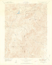
1948 Map of Mount Big Chief
USGS Topo · Published 1953About this map
Pike National Forest dominates this mountain landscape, which in the late 1940s was characterized by a network of high-altitude ranches and recreational retreats. The area south of Mount Big Chief served as a rugged corridor where the Gold Camp Road winds past established outposts like Rosemont and Broadmoor Lodge. These settlements, along with the Penrose-Rosemont Reservoir, reflect the early 20th-century development of the region for tourism and water management.
Find a feature on this map
43 named features on this map. Tap any name to fly to it.
Don’t see what you’re looking for? This feature index may not catch every label — zoom into the map to look around manually.
Map Details
Editions of this 1948 Mount Big Chief Map
2 editions found
Other maps of this area

1893 · Colorado Springs
USGS Topo · 1:125,000

1894 · Pikes Peak
USGS Topo · 1:125,000

1901 · Pikes Peak
USGS Topo · 1:125,000

1901 · Pikes Peak
USGS Topo · 1:62,500

1909 · Colorado Springs
USGS Topo · 1:125,000

1942 · Colorado Springs
USGS Topo · 1:125,000

1948 · Mount Big Chief
USGS Topo · 1:24,000

1948 · Mount Pittsburg
USGS Topo · 1:24,000

1948 · Timber Mountain
USGS Topo · 1:24,000

1948 · Manitou Springs
USGS Topo · 1:24,000