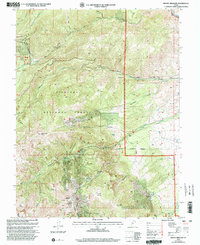
2001 Map of Mount Brigham
USGS Topo · Published 2003About this map
The high-altitude mining landscapes of Fishlake National Forest dominate this Piute County region at the turn of the 21st century. High peaks such as Mount Brigham, Edna Peak, and Copper Belt Peak tower over a complex network of canyons and gulches that fueled the local mineral economy for generations. Evidence of this extractive history is found at the Silver King Mine, Rainbow Mine, and the sprawling Deer Trail Mine near Deer Trail Mountain.
Find a feature on this map
48 named features on this map. Tap any name to fly to it.
Don’t see what you’re looking for? This feature index may not catch every label — zoom into the map to look around manually.
Map Details
Editions of this 2001 Mount Brigham Map
This is the sole edition of this map. No revisions or reprints were ever made.
Other maps of this area

1885 · Beaver
USGS Topo · 1:250,000

1932 · Sevier
USGS Topo · 1:62,500

1935 · Sevier
USGS Topo · 1:62,500

1937 · Delano Peak
USGS Topo · 1:48,000

1940 · Monroe
USGS Topo · 1:62,500

1943 · Delano Peak
USGS Topo · 1:62,500

1944 · Monroe
USGS Topo · 1:62,500

1945 · Marysvale
USGS Topo · 1:62,500

1947 · Marysvale
USGS Topo · 1:62,500

1953 · Richfield
USGS Topo · 1:250,000