
1970 Map of Mount Carmel
USGS Topo · Published 1972About this map
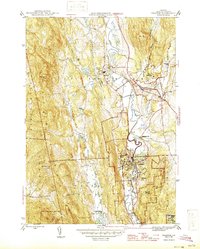
Mount Carmel State Forest and the vast Green Mountain National Forest dominate this 1970s topographical survey of the high country where Rutland, Windsor, and Addison Counties meet. The landscape is defined by steep ridges and narrow gaps, with the Neshobe River cutting through the northwest near Goshen Four Corners. This era of the forest is marked by recreational and fire-watch infrastructure, including the Lookout Tower atop Mount Carmel and seasonal sites like Sunrise Camp and Chittenden Brook Campground.
Find a feature on this map
67 named features on this map. Tap any name to fly to it.
Don’t see what you’re looking for? This feature index may not catch every label — zoom into the map to look around manually.
Map Details
Editions of this 1970 Mount Carmel Map
This is the sole edition of this map. No revisions or reprints were ever made.
Other maps of this area

1891 · Rutland
USGS Topo · 1:62,500

1893 · Rutland
USGS Topo · 1:62,500

1895 · Castleton
USGS Topo · 1:62,500

1897 · Castleton
USGS Topo · 1:62,500

1902 · Brandon
USGS Topo · 1:62,500

1904 · Brandon
USGS Topo · 1:62,500

1915 · Rochester
USGS Topo · 1:62,500

1917 · Rochester
USGS Topo · 1:62,500

1920 · Brandon
USGS Topo · 1:62,500
1944 · Proctor
USGS Topo · 1:31,680