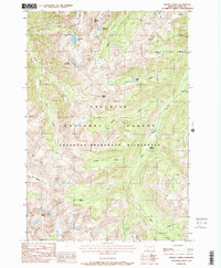
1987 Map of Mount Cowen
USGS Topo · Published 1988About this map
Mount Cowen stands as the dominant summit in this high-altitude landscape within the Absaroka-Beartooth Wilderness. The topography is defined by sharp peaks and a dense network of glacial lakes and drainage forks, including Pine Creek Lake, Jewel Lake, and Elbow Lake. Significant elevation changes are marked by features like Mount McKnight and Black Mountain, which overlook the headwaters of the Boulder River and West Boulder River. The 1980s data illustrates a protected backcountry environment within the Gallatin National Forest, characterized by steep drainages like Jungle Creek and Tumble Creek. The lack of road infrastructure emphasizes the region's character as a managed wilderness area, where landmarks such as Marten Peak and the high-elevation Beaver Meadows serve as primary points of orientation for navigation.
Find a feature on this map
27 named features on this map. Tap any name to fly to it.
Don’t see what you’re looking for? This feature index may not catch every label — zoom into the map to look around manually.
Map Details
Editions of this 1987 Mount Cowen Map
This is the sole edition of this map. No revisions or reprints were ever made.
Other maps of this area

1891 · Livingston
USGS Topo · 1:250,000

1893 · Livingston
USGS Topo · 1:250,000

1940 · Mt. Cowen
USGS Topo · 1:62,500

1943 · Mt Cowen
USGS Topo · 1:62,500

1947 · Bozeman
USGS Topo · 1:250,000

1948 · Bozeman
USGS Topo · 1:250,000

1951 · Mount Rae
USGS Topo · 1:24,000

1951 · Brisbin
USGS Topo · 1:24,000

1951 · Livingston Peak
USGS Topo · 1:24,000

1955 · Bozeman
USGS Topo · 1:250,000