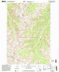
2000 Map of Mount Cowen
USGS Topo · Published 2005About this map
Mount Cowen stands as the dramatic centerpiece of this high-altitude landscape, where the administrative boundaries of the Livingston Big Timber Ranger District meet. The map reveals a complex alpine environment protected within the Absaroka-Beartooth Wilderness and the broader Gallatin National Forest. This terrain is defined by its verticality, with prominent summits like Mount McKnight and Black Mountain overseeing a network of glacial basins. Water is a defining feature here, collected in high-country basins such as Pine Creek Lake, Lake McKnight, and Trapper Lake. These reservoirs feed numerous drainages, including the Boulder River and the headwaters of Pine Creek, which carve through the steep topography. The lack of roads or permanent structures reflects the primitive state of the wilderness area at the turn of the millennium, preserved for its natural character and remote watersheds like Jungle Creek and Tumble Creek.
Find a feature on this map
28 named features on this map. Tap any name to fly to it.
Don’t see what you’re looking for? This feature index may not catch every label — zoom into the map to look around manually.
Map Details
Editions of this 2000 Mount Cowen Map
This is the sole edition of this map. No revisions or reprints were ever made.
Other maps of this area

1891 · Livingston
USGS Topo · 1:250,000

1893 · Livingston
USGS Topo · 1:250,000

1940 · Mt. Cowen
USGS Topo · 1:62,500

1943 · Mt Cowen
USGS Topo · 1:62,500

1947 · Bozeman
USGS Topo · 1:250,000

1948 · Bozeman
USGS Topo · 1:250,000

1951 · Mount Rae
USGS Topo · 1:24,000

1951 · Brisbin
USGS Topo · 1:24,000

1951 · Livingston Peak
USGS Topo · 1:24,000

1955 · Bozeman
USGS Topo · 1:250,000