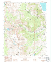
1992 Map of Mount Dana
USGS Topo · Published 1995About this map
Mount Dana and the surrounding high Sierra peaks define this landscape at the intersection of several protected wilderness areas. The map details the transition from the jagged summits of the Dana Plateau and Mount Warren down toward the western shores of Mono Lake. Cultural footprints in this high-altitude terrain are marked by mining history at the May Lundy Mine and the Log Cabin Mine, where associated Tailings and a Shaft are still indicated.
Find a feature on this map
53 named features on this map. Tap any name to fly to it.
Don’t see what you’re looking for? This feature index may not catch every label — zoom into the map to look around manually.
Map Details
Editions of this 1992 Mount Dana Map
This is the sole edition of this map. No revisions or reprints were ever made.
Other maps of this area

1901 · Mt. Lyell
USGS Topo · 1:125,000

1909 · Bridgeport
USGS Topo · 1:125,000

1911 · Bridgeport
USGS Topo · 1:125,000

1920 · Bridgeport
USGS Topo · 1:125,000

1947 · Mariposa
USGS Topo · 1:250,000

1948 · Walker Lake
USGS Topo · 1:250,000

1948 · Mariposa
USGS Topo · 1:250,000

1953 · Mono Craters
USGS Topo · 1:62,500

1956 · Matterhorn Peak
USGS Topo · 1:62,500

1956 · Tuolumne Meadows
USGS Topo · 1:62,500