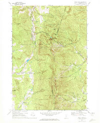
1971 Map of Mount Ellen
USGS Topo · Published 1972About this map
Mount Ellen and the high ridges of the Green Mountain National Forest anchor this early 1970s landscape, a period when Vermont's alpine recreation industry was firmly established. The map details the developed runs of Mad River Glen Ski Area, Glen Ellen Ski Area, and Sugarbush Valley Ski Area, which sit in contrast to the quiet valleys below. Local history is preserved in small settlements like Hanksville, Jerusalem, and Downingville, while the Gore Cem and Little Ireland Cem point to the area's early 19th-century pioneer origins. The rugged terrain is traversed by the historic Long Trail and the Appalachian Trail, following the ridgeline past Stark Mountain and Cutts Peak. In the lowlands, the Huntington River and various mountain brooks like Beaver Meadow Brook define the rural topography of Buels Gore and Starksboro.
Find a feature on this map
51 named features on this map. Tap any name to fly to it.
Don’t see what you’re looking for? This feature index may not catch every label — zoom into the map to look around manually.
Map Details
Editions of this 1971 Mount Ellen Map
Other maps of this area

1903 · Middlebury
USGS Topo · 1:62,500

1905 · Middlebury
USGS Topo · 1:62,500

1906 · Burlington
USGS Topo · 1:62,500

1919 · Burlington
USGS Topo · 1:62,500

1919 · Lincoln Mountain
USGS Topo · 1:62,500

1920 · Lincoln Mountain
USGS Topo · 1:48,000

1920 · Middlebury
USGS Topo · 1:62,500

1921 · Richmond
USGS Topo · 1:48,000

1921 · Lincoln Mountain
USGS Topo · 1:62,500

1924 · Camels Hump
USGS Topo · 1:62,500