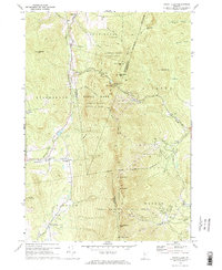
1971 Map of Mount Ellen
USGS Topo · Published 1972About this map
Stark Mountain and the high ridges of the Green Mountains dominate this central Vermont landscape during the early 1970s. The map illustrates a transitional period for the region's economy, where traditional upland settlements like Jerusalem and Hanksville sit in the valleys while the peaks are being reshaped for recreation. The burgeoning ski industry is clearly marked by the complex lift networks of the Mad River Glen Ski Area, Glen Ellen Ski Area, and Sugarbush Valley Ski Area.
Find a feature on this map
59 named features on this map. Tap any name to fly to it.
Don’t see what you’re looking for? This feature index may not catch every label — zoom into the map to look around manually.
Map Details
Editions of this 1971 Mount Ellen Map
Other maps of this area

1903 · Middlebury
USGS Topo · 1:62,500

1905 · Middlebury
USGS Topo · 1:62,500

1906 · Burlington
USGS Topo · 1:62,500

1919 · Burlington
USGS Topo · 1:62,500

1919 · Lincoln Mountain
USGS Topo · 1:62,500

1920 · Lincoln Mountain
USGS Topo · 1:48,000

1920 · Middlebury
USGS Topo · 1:62,500

1921 · Richmond
USGS Topo · 1:48,000

1921 · Lincoln Mountain
USGS Topo · 1:62,500

1924 · Camels Hump
USGS Topo · 1:62,500