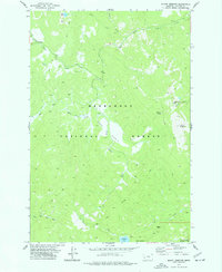
1974 Map of Mount Emerine
USGS Topo · Published 1977About this map
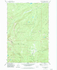
The Deerlodge National Forest dominates this mid-1970s terrain, revealing a landscape defined by high-elevation drainage systems and remote resource extraction. The summit of Mount Emerine serves as a central anchor for the local topography, overlooking the headwaters of numerous tributaries including Sand Basin Creek and North Fork Rock Creek. Evidence of early industrial activity persists at the Congdon Mine near Elk Creek, while the network of infrastructure is comprised almost entirely of an extensive system of pack trails, including the Crystal Creek Pack Tr. A Lookout Tower positioned near the peaks and isolated water bodies like Fuse Lake and Medicine Lake indicate a focus on fire observation and wilderness management within this part of Granite County. The absence of primary roads highlights the primitive nature of the area during this era, where movement relied on the established Pack Trail network.
Find a feature on this map
18 named features on this map. Tap any name to fly to it.
Don’t see what you’re looking for? This feature index may not catch every label — zoom into the map to look around manually.
Map Details
Editions of this 1974 Mount Emerine Map
This is the sole edition of this map. No revisions or reprints were ever made.
Other maps of this area

1909 · Sapphire
USGS Topo · 1:125,000

1947 · Butte
USGS Topo · 1:250,000

1958 · Butte
USGS Topo · 1:250,000

1960 · Butte
USGS Topo · 1:250,000

1962 · Butte
USGS Topo · 1:250,000

1971 · Stony Creek
USGS Topo · 1:24,000
1974 · Stony Creek
USGS Topo · 1:24,000
1974 · Skalkaho Pass
USGS Topo · 1:24,000
1974 · Burnt Fork Lake
USGS Topo · 1:24,000
1974 · Whetstone Ridge
USGS Topo · 1:24,000